| KML - Google Earth Keyhole Markup Language |
|
|
Prírodovedecká fakulta Univerzity Komenského | |
|
| |
|
Využitý element "LookAt" <LookAt> <longitude>17.0700733276645</longitude> <latitude>48.1477618935761</latitude> <altitude>1800</altitude> <heading>220</heading> <tilt>60</tilt> <range>900</range> <altitudeMode>clampToGround</altitudeMode> </LookAt> ďalšie informácie sú prevzaté zo stránky Google KML reference Description Defines a virtual camera that is associated with any element derived from Feature. The LookAt element positions the "camera" in relation to the object that is being viewed. In Google Earth, the view "flies to" this LookAt viewpoint when the user double-clicks an item in the Places panel or double-clicks an icon in the 3D viewer. Elements Specific to LookAt <longitude> Longitude of the point the camera is looking at. Angular distance in degrees, relative to the Prime Meridian. Values west of the Meridian range from -180 to 0 degrees. Values east of the Meridian range from 0 to 180 degrees. <latitude> Latitude of the point the camera is looking at. Degrees north or south of the Equator (0 degrees). Values range from -90 degrees to 90 degrees. <altitude> Distance from the earth's surface, in meters. Interpreted according to the LookAt's altitude mode. <heading> Direction (that is, North, South, East, West), in degrees. Default=0 (North). (See diagram below.) Values range from 0 to 360 degrees. <tilt> Angle between the direction of the LookAt position and the normal to the surface of the earth. (See diagram below.) Values range from 0 to 90 degrees. Values for <range> (required) Distance in meters from the point specified by <longitude>, <latitude>, and <altitude> to the LookAt position. (See diagram below.) <altitudeMode> Specifies how the <altitude> specified for the LookAt point is interpreted. Possible values are as follows: - clampToGround - (default) Indicates to ignore the <altitude> specification and place the LookAt position on the ground. - relativeToGround - Interprets the >altitude> as a value in meters above the ground. - absolute - Interprets the <altitude> as a value in meters above sea level. 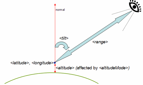
| |
| © Vladimír Bačík | Katedra humánnej geografie a demogeografie | Prírodovedecká fakulta | UK Bratislava | |